Physical Resilience
KIPDA Region Physical Resilience
Building a resilient region is critical to withstanding and recovering from natural disasters. Without physical resilience, businesses cannot reopen, and our most vulnerable populations lack access to the care they need. To improve on the region’s resiliency, part of KIPDA’s actions are to develop hazard mitigation planning and other resiliency projects.
The National Risk Index uses data for natural hazard and community risk factors to develop a baseline relative risk measurement for each county. It was designed and built by FEMA in close collaboration with various stakeholders and partners in academia; local, state, and federal government; and private industry.
The 18 natural hazards used for the index include avalanche, coastal flooding, cold wave, drought, earthquake, hail, heat wave, hurricane, icestorm, landslide, lightning, riverine flooding, strong wind, tornado, tsunami, volcanic activity, wildfire, and winter weather. The Risk Index scores are calculated using an equation that combines scores for Expected Annual Loss due to natural hazards, Social Vulnerability, and Community Resilience.
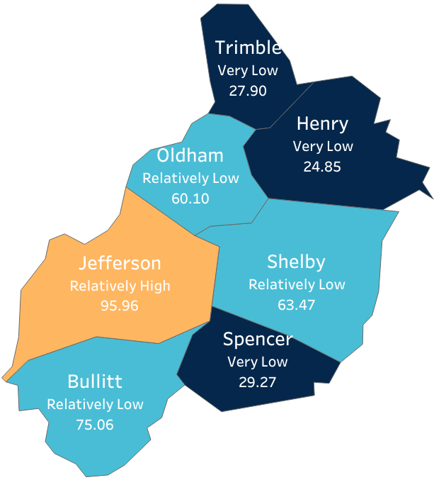
Oldham, Shelby, and Bullitt risk level were “relatively low” with Trimble, Henry, and Spencer being designated as “very low” risk. Jefferson had the highest risk score of 95.96 which places the county at “relatively high” risk. The top five hazard risks include tornado, ice storm, drought, riverine flooding, and landslide. The expected annual loss for the region from natural hazards is $154.95 million. See the full FEMA National Risk Index report for the region here: National Risk Index Report.
In previous years, flooding had not been identified as a top five risk for the region based on the average National Risk Index. It is interesting to see that flooding broke into the top five for the KIPDA region this year. Flooding is one of the most expensive natural hazards to recover from. A significant portion of the total land in the KIPDA region is in a floodplain, which includes over 20,000 buildings that are vulnerable. KIPDA ranks the probability of flooding events as “extremely high” in its Hazard Mitigation Plan. Between 2000 and 2020 (21 years), the KIPDA region experienced 65 distinct flooding and heavy rain events. Flooding is also significant in Kentucky specifically due to the increased risk of dam failures. The region has 136 dams with an average age of 59 years according to the National Inventory of Dams. 47 of these dams have received a “significant” or “high” hazard potential classification.
Flooding is a significant risk in the region and is expected to get worse over time. Heavy precipitation in the Kentuckiana region will increase in the future. This will put strain on critical infrastructure, agriculture, housing, healthcare facilities, and others. These types of natural hazard events will require stringent planning to increase resiliency.
The KIPDA region actively pursues greater physical resilience through hazard mitigation planning and projects. To understand the natural hazards our region faces and the steps our region is taking to strengthen resilience, check out our online 2021 Regional Hazard Mitigation Plan.
")
")
Sources:
National Inventory of Dams
2021 KIPDA Regional Hazard Mitigation Plan
FEMA National Risk Index
Incorporate by Reference:
KIPDA Climate Change Report